

PHOTOS
TOP: The Kopka struggles to become a river.
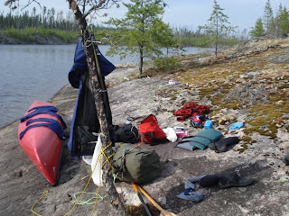
MIDDLE : nice view from this campsite . Note skeletons of burned trees in background rising above the new stuff.
BOTTOM : My gear spread out on the rocks after a long day before I set the tent up.
***********************************************************************
Day 3 and it's another nice hot day. Waterhouse Lake is a straight forward paddle and once again the wind is at my back. Just before entering Gaal Lake I note a really nice "A" camsite on the left on a rise of land. It has a great view. After Gaal lake the Kopka becomes a real stream. It's small, narrow and has quiet sections as well as occasional rocky little rapids. Still not big enough that you'd ever call it a river.
I was able to run most of these rapids, lining a litle bit of one and having to jump out and get off a rock I was hung up on another. No real portages. If there had been a little more water theses maneuvers would have been unneccessary and as I mentioned, fine for tandem boaters too. As it was, I was glad to be in the SuperNova with its agility. At one time(from old MNR notes), one of these rapids had a lot of deadfalls and was impassable but I encountered no such obstacles. . . .of course things can change from year to year. Some of these rapids deserve a CL II/II+ rating for their technical requirements, others strictly class I. They weren't steep enough to be considered dangerous however , just demanding. In a tandem canoe you'd maybe be doing a lot of jumping out at these levels because of the rocks. More water would resolve that problem.
The little unamed lake after Gaal Lake has a small "B" campsite on the south shore. After you enter the river again there are several more rapids again demanding some technical ability to negotiate. Some are quite rocky. All in all a lot of fun.
Day 3 turned out to be the longest paddle day (17 miles!) because I could not find a suitable campsite where I thought there would be one. The Kopka has a final rapid before it enters Uneven Lake and there I was expecting to find a campsite based on my 20 yo MNR notes. Nno such luck! I couldn't even find a remnant. Should have maybe pitched on the south shore 1/2 mile into Uneven Lake where I saw a sandy little beach where a stream entered but I thoght I could do better. . . not! So, I kept paddling 5 more miles. The landscape turned Outwordly as fire-devastated land took over, eerily quiet. Finally pitched camp on bare rock site, albeit with a decent view, and little trees and shrubby plants all around trying to survive another year. Had another swim; it was HOT; I was tired.
No comments:
Post a Comment